
[awesome-weather owm_city_id=”2800866″ location=”Brussels, BE” size = “wide” units=”F” forecast_days=”5″ show_link=”1″ background_by_weather=”1″ hide_attribution=”1″ show_icons=”1″]
Remnants of early human settlements from the stone age have been found. The Romans occupied the area after the decline of the empire it became part of the Frankish Kingdom. The founding of current of Brussels is considered 979. It has been affiliated through the centuries with many powers starting with the County of Leuven and others like Spain, Austria, Netherlands and France. After the Belgian Revolution of 1830 it became the capital of the new established Kingdom of Belgium.
Brussels was invaded and occupied in both World Wars by Germany. In the later 20th century it became very modernized hosting a worlds fair in 1958. It also became the center of politically policy in Europe as the capital of the European Union and the headquarters for NATO.
Brussels is a bi-lingual community with a Flemish Dutch speaking community and Walloon French speaking one. Visiting Brussels is a cultural delight with architecture, museums, festivals, restaurants and its centre a UNESCO World Heritage site.
Regions of Brussels…
- Centre
- Pentagon
- European Quarter
- Heysel
- Business District
- Woluwe
- Matongé
- North-East
- South
- West
- Sonian Forest
- Molenbeek
- Schaarbeek
- Industrial District
Points of Interests in Brussels…
| Name | Type | Class | Area | District |
|---|---|---|---|---|
| Grand Place 🏛 | Landmark | City Square | Centre | Grand Place |
| City Hall | Landmark | Historic Bldg. | Centre | Grand Place |
| King’s House | Landmark | Historic Bldg. | Centre | Grand Place |
| Manneken Pis | Landmark | Statue | Centre | |
| The Mint | Landmark | Opera House | Centre | |
| European Parliament | Landmark | Building | European Quarter | |
| Parlamentarium | Landmark | Building | European Quarter | |
| Cinquantenaire Park | Natural | City Park | European Quarter | |
| Cinquantenaire Museum | Museum | Art & History | European Quarter | Cinquantenaire Park |
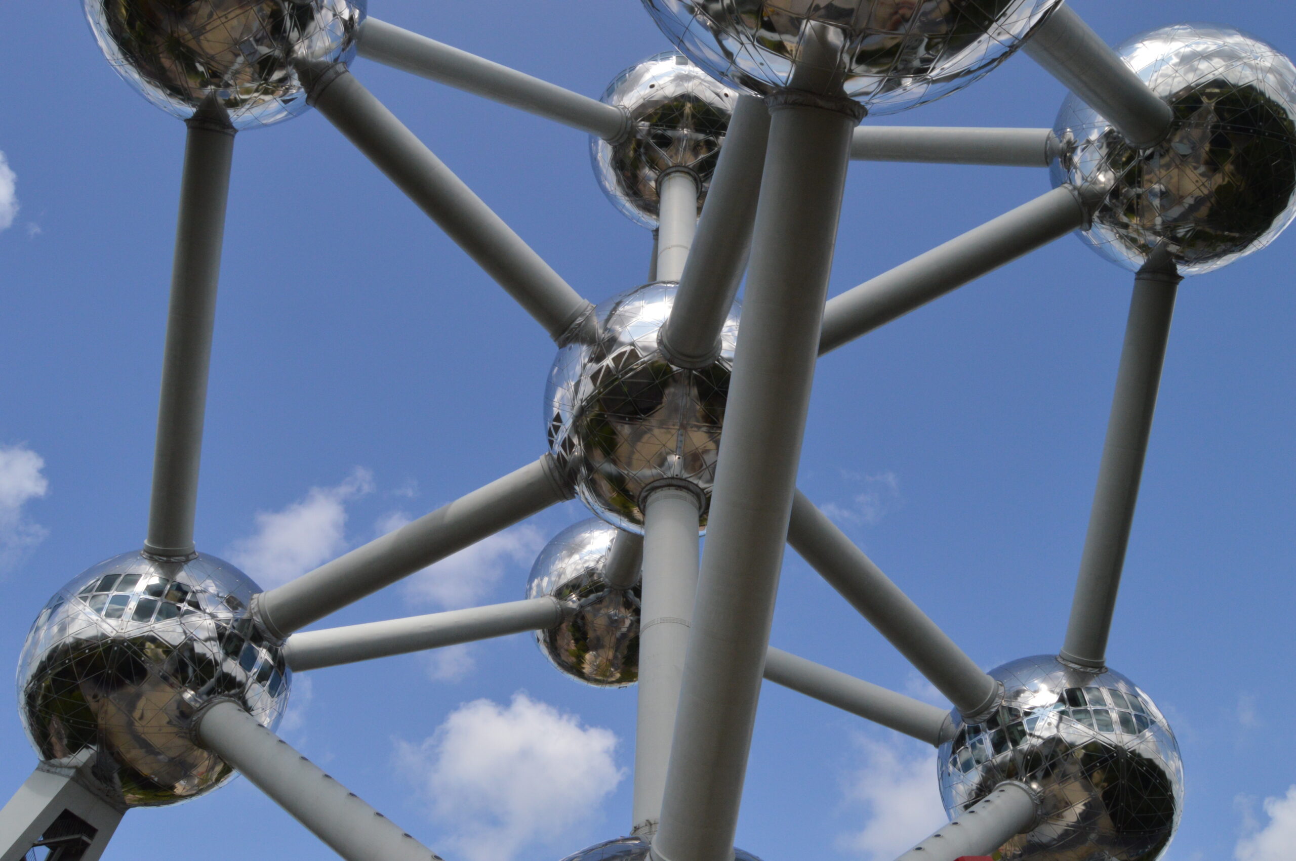
| Atomium | Landmark | Historic Structure | Heysel | Heysel Plateau |
| Centenary Palace | Landmark | Exhibition Center | Heysel | Heysel Plateau |
| Mini-Europe | Entertainment | Mini Amusement | Heysel | Heysel Plateau |
| Royal Crypt | Landmark | Burial Crypt | Heysel | Royal Area |
| Hill of Arts | Neighborhood | Arts Area | Pentagon | |
| Martyrs’ Square | Landmark | City Square | Pentagon | |
| Halle Gate | Landmark | City Gate | Pentagon |
Day Trips from Brussels…
- Aachen
- Amsterdam
- Antwerp
- Bastogne/ Bulge Battlefield
- Bruges 🏛
- Dinant
- Flanders Fields / WWI Battlefields
- Ghent 🏛
- Leuven 🏛
- Liége
- Luxembourg 🏛
- Mechelen 🏛
- Monschau
- Namur 🏛
- Waterloo Battlefield
- Ypres
Transportation in Brussels…
✈️ Airports
Brussels is served by two airports. Brussels Airport is the main airport and the most convenient for flights and transportation. Brussels South Charieroi Airport is an alternative to the south of the city with low cost airline carriers.
BRU Brussels Airport – Located 15 km northeast of the city with easy train transportation into the city center stations. There are non-stop flights to 6 US cities. Multiple bus line lines from MIVB/STIB or De Lijn are your next best options followed by taxi or Uber.
CRL Brussels South Charieroi Airport – Located 42 km from the city is serviced heavily by low cost carriers like Ryanair, Wizzair. Transportation to Brussels is by Brussels City Shuttle or Tech-bus A. Taxi cost is high because of the distance to the city.
🚊 Public Transportation
Suburban Train: NMBS/SNCB S Train (S-Bahn suburban trains) (route map)
#S1 line, Nivelles↔︎NSC↔︎Mechelen↔︎Antwerp
#S2 line, Braine-le-Comte↔︎NSC↔︎Leuven
#S3 line, Zottegem↔︎NSC↔︎Dendermonde
#S4 line, Aalst-Etterbeek↔︎Merode↔︎Vilvoorde
#S5 line, Geraardsbergen↔︎Schuman-Josaphat tunnel↔︎Mechelen
#S6 line, Schaarbeek↔︎NSC↔︎Geraardsbergen↔︎Denderleeuw
#S7 line, Halle↔︎Merode↔︎Mechelen via Hofstade
#S8 line, Louvain-la-Neuve↔︎NSC↔︎Brussels-South
#S81 line, Ottignies↔︎Schaarbeek
#S9 line, Braine-l’Alleud ↔︎ Schuman-Josaphat tunnel ↔︎ Leuven
#S10 line, Aalst ↔︎ NSC↔︎ -Brussels West ↔︎ Dendermonde
#S20 line, Ottignies ↔︎ Leuven
NSC, is north south connection with stops at all Brussels stations in the city center.
Brussels Train Stations
Brussels North (French: Bruxelles-Nord (STIB: Gare du Nord), Dutch: Brussel-Noord (MIVB: Noordstation))
Brussels Congress (French: Bruxelles-Congrès, Dutch: Brussel-Congres)
Brussels Central (French: Bruxelles-Central (STIB: Gare Centrale), Dutch: Brussel-Centraal (MIVB: Centraal Station))
Brussels Chapel (French: Bruxelles-Chapelle, Dutch: Brussel-Kapellekerk)
Brussels South (French: Bruxelles-Midi (STIB: Gare du Midi), Dutch: Brussel-Zuid (MIVB: Zuidstation)) (the Eurostar, Thalys, TGV and ICE international terminal)
Light Rail / Tram: STIB-MIVB (Brussels premetro)(route map)
#T 3 Line, Esplanade ↔︎ Churchill
#T4 Line, Gare du Nord ↔︎ Noordstation to Stalle car park
#T7 Line, Heysel ↔︎ Heizel to Vanderkindere
#T25 Line, Rogier to Gare de Boondael ↔︎ Boondaal station
Metro / Subway: STIB-MIVB (Brussels Metro)(route map)
#M Line 1, Gare de l’Ouest ↔︎ Weststation to Stockel ↔︎ Stokkel
#M Line 2, Simonis ↔︎ Elisabeth
#M Line 5, Erasme / Erasmus ↔︎ Herrmann-Debroux
#M Line 6, Roi Baudouin / Koning Boudewijn ↔︎ Elisabeth
City Bus: STIB-MIVB (network map)
50 lines (+11 night routes)
Bicycles:Villo
Transit Cards / Passes:Brussels Card