
[awesome-weather owm_city_id=”3173435″ location=”Milan, IT” size = “wide” units=”F” forecast_days=”5″ show_link=”1″ background_by_weather=”1″ hide_attribution=”1″ show_icons=”1″]
Madrid is the Capitol of Spain.
Regions of Madrid…
Latras & Lavapiés
La Latina & Austrias
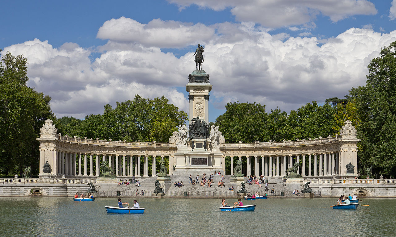
Retiro
Salamanca
Malasaña & Chueca
Arganzuela
Moncloa
Chamberí & Castellana
South Suburbs
North Suburbs
Points of Interests in Madrid…
| Name | Type | Class | Area | District |
|---|---|---|---|---|
| Arco de la Victoria | Landmark | Triumph Arch | Moncloa | |
| Atocha | Transportation | Train Station | Arganzuela | |
| Barajas International | Transportation | Airport | Northern Suburbs | |
| Basílica La Milagrosa | Landmark -Reilgious | Basilica | Chamberí & Castellana | |
| CaixaForum Madrid | Museum | Archeology / Art / Architecture | Retiro & Paseo del Arte | |
| Calle Serrano | Landmark / Shopping | Shopping Street | Salamanca | |
| Casa de Campo | Natural | City Park | Moncloa | |
| Casa Gallardo | Landmark | Art Nouveau Bldg | Moncloa | |
| Catedral de la Almudena | Landmark-Religious | Cathedral | La Latina & Austrias | |
| El Capricho | Natural | City Park | Northern Suburbs | |
| El Capricho | Landmark | City Park | Salamanca | |
| El Rastro | Shopping | Flea Market | La Latina & Austrias | |
| El Retiro Park | Natural | City Park | Retiro & Paseo del Arte | |
| Faro de Moncloa | Landmark | Tower | Moncloa | |
| Faunia | Attraction | Zoo | Southern Suburbs | |
| Four Towers | Landmark | Chamberí & Castellana | ||
| Geo-mining Museum | Museum | Minerals | Chamberí & Castellana | |
| Gran Vía | Landmark | Boulevard | Latras & Lavapiés | |
| Hospital de Maudes | Landmark | Chamberí & Castellana | ||
| Juan March Institute | Museum | Art | Salamanca | |
| King Charles III | Landmark | Statue | Latras & Lavapiés | Puerta del Sol |
| La Tabacalera | Museum | Alternative Art | Latras & Lavapiés | |
| Las Ventas Bullring | Landmark | Bull Ring | Salamanca | |
| Longoria Palace | Landmark | Palace | Malasaña & Chueca | |
| Madrid Zoo Aquarium) | Attraction | Zoo / Aquarium | Moncloa | |
| Madrid-Chamartín | Transportation | Train Station | Chamberí & Castellana | |
| Mariblanca statue | Landmark | Statue | Latras & Lavapiés | Puerta del Sol |
| MCNM | Museum | Natural Sciences | Chamberí & Castellana | |
| Mercado de la Cebada | Landmark | Market | La Latina & Austrias | |
| Mercado de San Miguel | Landmark / Shopping | Market | La Latina & Austrias | Plaza Mayor |
| MUNCYT | Museum | Science / Technology | Northern Suburbs | |
| Museo de América | Museum | History | Moncloa | |
| Museo de San Isidro | Museum | Paleontology and Archaeology | La Latina & Austrias | |
| Museo del Prado | Museum | Classical Art | Retiro & Paseo del Arte | |
| Museo Naval de Madrid | Museum | Nautical Art | Retiro & Paseo del Arte | |
| Museum of History of Madrid | Museum | History | Malasaña & Chueca | |
| Museum of Lázaro Galdiano | Museum | Fine Arts | Salamanca | |
| National Archeology Museum | Museum | Archeology | Salamanca | |
| National Museum of Anthropology | Museum | Anthropology | Retiro & Paseo del Arte | |
| New Ministries | Landmark | Chamberí & Castellana | ||
| Palacio Rea | Landmark | Royal Palace | La Latina & Austrias | |
| Parque Madrid Río | Natural | Riverwalk / Park | Arganzuela | |
| Planetarium of Madrid | Museum | Planetarium | Arganzuela | |
| Platform 0 – Chamberí Station | Museum | Ghost Station | Chamberí & Castellana | |
| Plaza de Castilla | Landmark | Chamberí & Castellana | ||
| Plaza de Castilla | Landmark | City Plaza | Northern Suburbs | |
| Plaza de Cibeles | Museum | City Plaza | Retiro & Paseo del Arte | |
| Plaza de Colón | Landmark | City Ppaza | Salamanca | |
| Plaza de España | Landmark | Moncloa | ||
| Plaza de la Villa | Landmark | City Plaza | La Latina & Austrias | |
| Plaza de Olavide | Landmark | Chamberí & Castellana | ||
| Plaza del Dos de Mayo | Landmark | City Plaza | Malasaña & Chueca | |
| Plaza Mayor | Landmark | City Plaza | La Latina & Austrias | |
| Puerta del Sol | Landmark | City Plaza | Latras & Lavapiés | |
| Railway Museum of Madrid | Museum | Railroad | Arganzuela | |
| Real Academia de Bellas Artes de San Fernando | Museum | Fine Arts | Latras & Lavapiés | |
| Reina Sofía National Museum | Museum | 20th Century Art | Retiro & Paseo del Arte | |
| Rosaleda Gardens | Natural | Gardens | Moncloa | |
| Royal Botanical Garden of Madrid | Natural | Gardens | Retiro & Paseo del Arte | |
| Royal Chapel of St. Anthony of La Florida | Landmark – Religious | Church | Moncloa | |
| Royal Post Office | Landmark | PO Bldg | Latras & Lavapiés | Puerta del Sol |
| Teatro Real | Entertainment | Opera House | La Latina & Austrias | |
| Templo de Debod | Landmark / Natural | Temple / Park | Moncloa | |
| The Costume Museum | Museum | Costumes | Moncloa | |
| Thyssen-Bornemisza Museum | Museum | Fine Art | Retiro & Paseo del Arte | |
| Torres de Colón | Landmark | Twin Tower Bldgs | Chamberí & Castellana | |
| Tribunal Constitucional | Landmark | Chamberí & Castellana |
Day Trips from Madrid…
- Alcalá de Henares 🏛
- Aranjuez 🏛
- Ávila 🏛
- Cordoba 🏛
- Cuenca 🏛
- El Escorial 🏛
- La Mancha
- Ribera del Duero Wine region
- Salamanca 🏛
- Segovia 🏛
- Toledo 🏛
- Valley of the Fallen
Transportation in Madrid…
✈️ Airports
Madrid has one primary international airport.
MAD Madrid Barajas International Airport – Located 13 km northeast of the city center it has 4 US cities. Transportation available to the city center on Metro line 8 (pink) from terminals 1-2-3 to Nuevos Ministerios. Renfe regonal train from C1 to Puerto de Atocha station. Bus service is Exprés Aeropuerto bus 203, Bus 200 to Avenida de America transport hub. Other bus lines run to other areas of the city
🚊 Public Transportation
Suburban Train: Renfe (Cercanías) (route map)
C-1 line, Príncipe Pío ↔︎ Atocha ↔︎ Chamartín ↔︎ Aeropuerto T4
C-2 line, Chamartín ↔︎ Atocha ↔︎ Alcalá de Henares ↔︎ Guadalajara
C-3 line, Chamartín ↔︎ Atocha ↔︎ Aranjuez
C-3A line, Santa María de la Alameda ↔︎ El Escorial ↔︎ Villalba ↔︎ Chamartín ↔︎ Atocha ↔︎ Aranjuez
C-4 line, Alcobendas-San Sebastián de los Reyes/Colmenar Viejo ↔︎ Chamartín ↔︎ Atocha ↔︎ Parla
C-5 line, Móstoles-El Soto ↔︎ Atocha ↔︎ Humanes
C-7 line, Príncipe Pío ↔︎ Chamartín ↔︎ Atocha ↔︎ Alcalá de Henares
C-8 line, Cercedilla ↔︎ Villalba – Chamartín ↔︎ Atocha ↔︎ Alcalá de Henares ↔︎ Guadalajara
C-9 line, Cercedilla ↔︎ Cotos
C-10 line, Villalba ↔︎ Príncipe Pío ↔︎ Atocha ↔︎ Chamartín ↔︎ Aeropuerto T4
Light Rail / Tram: MLM (light rail & mtro route map)
ML-1 line, Pinar de Chamartín ↔︎ Las Tablas
ML-2 line, Colonia Jardín ↔︎ Estación de Aravaca
ML-3 line, Colonia Jardín ↔︎ Puerta de Boadilla
ML-4 line, Parla Tram (circular route)
Metro / Subway: Metro Madrid (metro route map)
#1 line, Pinar de Chamartín ↔︎ Valdecarros
#2 line, Las Rosas ↔︎ Cuatro Caminos
#3 line, Villaverde Alto – Moncloa
#4 line, Argüelles – Pinar de Chamartín
#5 line, Alameda de Osuna – Casa de Campo
#6 line, (circular line)
#7 line, Hospital del Henares – Estadio Metropolitano – Pitis
#8 line, Nuevos Ministerios – Aeropuerto terminal 4
#9 line, Paco de Lucía – Puerta de Arganda – Arganda del Rey
#10 line, Hospital Infanta Sofía – Tres Olivos – Puerta del Sur
#11 line, Plaza Elíptica ↔︎ La Fortuna
# 12 line, Metro Sur (circular line)
R-Ramal line, Ópera station ↔︎ Principe Pio
City Bus: EMT Madrid
217 routes
Suburban Bus Operators
Aerial/Cable : Teleférico de Madrid, Parque del Oeste ↔︎ Casa de Campo
Bicycles: BiciMAD
Transit Cards / Passes: Madrid Tourist Pass