Europe is one of seven continents. It is the second smallest continent in size with only Oceania being smaller. Europe is a large peninsula that extends westerly out from the Eurasia super-continent land mass. Through the centuries the boundaries have shifted, that define Europe from Asia. Unlike other continents, mountains and rivers have been used to define the European-Asia boarders and Europe can be described as a sub-continent. Today it is excepted that the Ural Mountains and Ural river to the Caspian Sea define the border on the east. On the south the watershed of the Caucasus mountains from the Caspian to the Black Sea and through the Bosporus Strait to the Aegean Sea. On the south the Mediterranean Sea defines it from Africa west to the Atlantic Ocean. On the west the Atlantic Ocean forms a natural boundary as the Arctic Ocean does on the the north.
Geographical Features…
Europe is actually a collection of peninsulas with the two primary ones being the Fennoscandia in the north separated from the main European peninsula by the Baltic Sea in the south. The Fennoscandia has two major peninsulas, the Scandinavian and Kola. It is bounded on the north by the Arctic Ocean, on the west by the Atlantic Ocean and on the east by the White sea, gulf of Finland and Russia.
The primary European peninsula is bounded on the north by the Baltic Sea, on the west by the Atlantic Ocean, on the east by the Ural mountains and in the south the Mediterranean Sea separates it from Africa. The European peninsula has three major peninsulas extending for it, Iberia, Italy and the Balkan. Even these peninsulas have smaller ones that form the geographical shape of Europe.
This extraordinary shape of seas and land allowed early civilizations easy navigation between one settlement and others, allowing for easier communication and trade which spurred growth over the continent between its peoples. It isn’t surprising that over the centuries, ethnic peoples from the east in Asia, migrated west to the European continent.

Europe’s Most Visited Natural Locations
Click on the links to see the most desirable natural locations travelers to Europe want to see. ➾ Mountains-Glaciers-Valleys ➾ Rivers- Lakes – Waterfalls
Continents By Size
The total size of the land mass of earth is 148,429,00 Sq. Km (75,308,738 sq. miles). Europe is one of the smallest continents in size, only making up 6.7 % of earth’s total land mass.
Continent
Asia w/Middle East
Africa
North America
South America
Antarctica
Europe
Australia/Oceania
area sq. km
44,579,000
30,221,532
24,709,000
17,840,000
13,209,000
10,180,000
8.525,989
area sq. mi
17,212,000
11,608,599
9,540,000
6,890,000
5,400,000
3,930,000
3,291,903
% of earth
30.0 %
20.3 %
16.3 %
12.0 %
8.9 %
6.7 %
5.2 %
Listed below is the total land area for European countries and dependents . You may sort the table below by alpha country name, size or rank. Source: Central Intelligence Agency 2017.
Geographical Country Statistics..
Listed below is the total land area for European countries and dependents . You may sort the table below by alpha country name, size or rank. Source: Central Intelligence Agency 2017.| Country | Land Area (km2) | Land (mi2) | Eur. Rank | World Rank | Water Area (km2) | |
|---|---|---|---|---|---|---|
| Europe only Russia | (3,992,500) | (1542512) | ||||
| Turkey | 769,632 | 297,157 | 2 | 37 | 18,170 | |
| Ukraine | 579,330 | 223,680 | 4 | 46 | 24,200 | |
| Isle of Man | 572 | 221 | 43 | 0 | ||
| France | 549,970 | 212,344 | 3 | 43 | 1,530 | |
| Spain | 498,980 | 192,657 | 5 | 52 | 6,390 | |
| Andorra | 468 | 181 | 44 | 196 | 0 | |
| Sweden | 410,335 | 158,431 | 6 | 56 | 39,960 | |
| Jan Mayen | 377 | 146 | 45 | 0 | ||
| Germany | 348,672 | 134,623 | 7 | 63 | 8,350 | |
| Malta | 316 | 122 | 46 | 208 | 0 | |
| Norway | 304,282 | 117,483 | 9 | 68 | 19,520 | |
| Poland | 304,255 | 117,473 | 10 | 70 | 8,430 | |
| Finland | 303,815 | 117,303 | 8 | 65 | 34,330 | |
| Italy | 294,140 | 113,568 | 11 | 72 | 7,200 | |
| United Kingdom | 241,930 | 93,409 | 12 | 80 | 1,680 | |
| Romania | 238,391 | 92,043 | 13 | 83 | 8,500 | |
| Belarus | 207,600 | 80,154 | 14 | 86 | 4,700 | |
| Liechtenstein | 160 | 62 | 47 | 219 | 0 | |
| Greece | 131,957 | 50,948 | 15 | 97 | 1,310 | |
| Jersey | 116 | 45 | 48 | 0 | ||
| Bulgaria | 110,879 | 42,810 | 16 | 105 | 2,390 | |
| Iceland | 103,000 | 39,768 | 17 | 108 | 2,750 | |
| Hungary | 93,028 | 35,918 | 18 | 110 | 3,420 | |
| Portugal | 92,090 | 35,556 | 19 | 111 | 620 | |
| Austria | 83,871 | 32,382 | 20 | 114 | 1,426 | |
| Czechia | 78,876 | 30,454 | 21 | 116 | 1,620 | |
| Guernsey | 78 | 30 | 49 | 0 | ||
| Serbia | 77,474 | 29,912 | 22 | 117 | 0 | |
| Ireland | 70,273 | 27,132 | 23 | 120 | 1,390 | |
| Lithuania | 65,300 | 25,212 | 24 | 123 | 2,620 | |
| Latvia | 64,589 | 24,937 | 25 | 124 | 2,340 | |
| Svalbard | 61,022 | 23,561 | 26 | |||
| San Marino | 61 | 24 | 50 | 229 | 0 | |
| Croatia | 56,594 | 21,851 | 26 | 127 | 620 | |
| Bosnia & Herzegovina | 51,197 | 19,767 | 27 | 129 | 10 | |
| Slovakia | 49,035 | 18,932 | 28 | 131 | 930 | |
| Estonia | 45,228 | 17,462 | 29 | 133 | 2,840 | |
| Denmark | 43,094 | 16,638 | 30 | 134 | 660 | |
| Netherlands | 41,543 | 16,039 | 31 | 135 | 7,650 | |
| Switzerland | 41,227 | 15,917 | 32 | 136 | 1,280 | |
| Moldova | 33,851 | 13,069 | 33 | 140 | 960 | |
| Belgium | 30,528 | 11,786 | 34 | 141 | 250 | |
| Albania | 28,748 | 11,099 | 35 | 145 | 1,350 | |
| North Macedonia | 25,713 | 9,927 | 36 | 150 | 280 | |
| Slovenia | 20,273 | 7,827 | 37 | 155 | 122 | |
| Russia | 16,377,742 | 6,323,481 | 1 | 1 | 750,500 | |
| Montenegro | 13,812 | 5,332 | 38 | 162 | 360 | |
| Kosovo | 10,877 | 4,199 | 39 | 169 | 0 | |
| Cyprus | 9,251 | 3,571 | 40 | 171 | 10 | |
| Gibraltar | 6.8 | 2.6 | 51 | 0 | ||
| Luxembourg | 2,586 | 998 | 41 | 179 | 0 | |
| Monaco | 1.98 | 0.76 | 52 | 254 | 0 | |
| Faroe Islands | 1,393 | 538 | 42 | 0 | ||
| Holy See – Vatican | 0.44 | 0.169 | 53 | 257 | 0 |
European City Latitudes vs. USA…
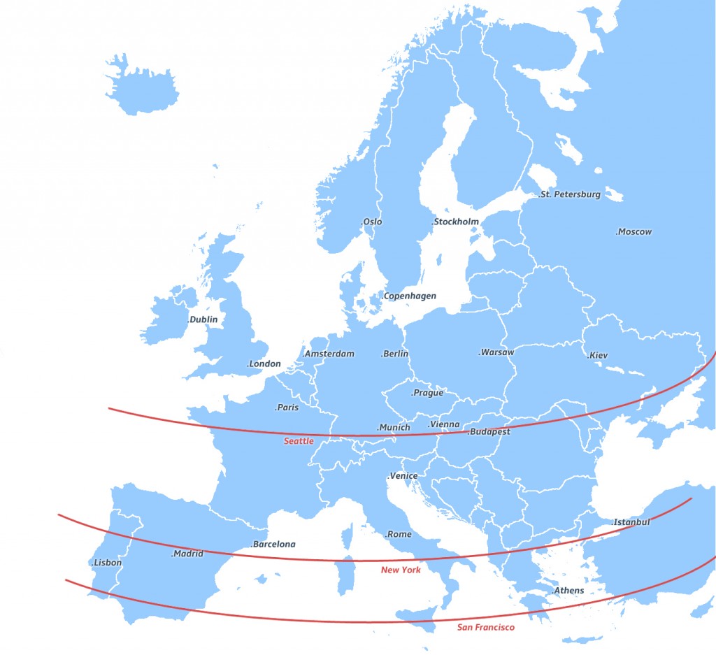
In relation to cities in the United States, one of our northernmost cities, Seattle lies at 47° latitude north, compared to London at 51°and Paris 48° north. One of continental Europe’s northernmost major cities is Helsinki at 59°north.
In the south Austin at 30° north lies parallel with Cairo, Egypt and Miami below that at 25° north. View the map and table to compare the equivalent latitudes of European cities to that of the United States.
The following table is the comparative latitude of major European cities to major cities in the U.S. starting with the northernmost location and heading south. Extreme and Mainland points of Europe are foot noted below.
Europe Location
Cape Fligely, Norway [1]
–
Cape Nordkinn, Norway [2]
Reykjavik, Iceland
–
Saint Petersburg, Russia
Stockholm, Sweden
Oslo, Norway
Edinburgh, Scotland, UK
Moscow, Russia
Copenhagen, Denmark
Dublin, Ireland
Berlin, Germany
Amsterdam, Netherlands
Warsaw, Poland
London, England, UK
Brussels, Belgium
Prague, Czechia
Kraków, Poland
Paris, France
Munich, Germany
Vienna, Austria
Zürich, Switzerland
–
Budapest, Hungary
–
Milan, Italy
Venice, Italy
–
Florence, Italy
Dubrovnik, Croatia
–
Rome, Italy
–
Barcelona, Spain
Istanbul, Turkey
–
Madrid, Spain
–
–
Lisbon, Portugal
Athens, Greece
–
Punta de Tarifa, Spain [4]
–
–
Gavdos, Greece [5]
–
–
–
–
–
–
–
–
Latitude
81° 50′ N
71° 23′ N
71° 10′ N
64° 04′ N
61° 13′ N
59° 57′ N
59° 56′ N
59° 54′ N
59° 20′ N
55° 55′ N
55° 45′ N
55° 40′ N
53° 20′ N
52° 30′ N
52° 22′ N
52° 14′ N
51° 32′ N
50° 52′ N
50° 05′ N
50° 04′ N
48° 48′ N
48° 08′ N
48° 14′ N
47° 21′ N
47° 37′ N
47° 30′ N
45° 31′ N
45° 27′ N
45° 26′ N
44° 58′ N
43° 47 N
42° 38′ N
42° 21′ N
41° 54′ N
41° 50′ N
41° 23′ N
41° 00′ N
40° 47′ N
41° 23′ N
39° 44′ N
38° 43′ N
38° 43′ N
37° 59′ N
37° 47′ N
36 00′ N
36° 10′ N
34° 48′ N
34° 03′ N
33° 45′ N
33° 27′ N
32° 46′ N
29° 57′ N
29° 45′ N
29° 45′ N
21° 18′ N
18° 55′ N
U.S. Location
–
Pt. Barrow, Alaska [3]
–
–
Anchorage, Alaska
–
–
–
–
–
–
–
–
–
–
–
–
–
–
–
–
–
–
Seattle, Washington
–
Portland, Oregon
–
–
Minneapolis, Minneapolis
–
–
Boston, Massachusette
–
Chicago, Illinois
_
–
New York, New York
–
Denver, Colorado
Washington, D.C.
–
–
San Francisco, California
–
Las Vegas, Nevada
Los Angeles, California
–
Atlanta, Georgia
Phoenix, Arizona
Dallas, Texas
New Orleans, Louisiana
Houston, Texas
Miami, Florida
Honolulu, Hawaii
Ka Lee, Hawaii [6]
[1] Northernmost extreme point of Europe, Cape Fligely, Norway
[2] Northernmost mainland point of Europe, Cape Nordkinn, Norway
[3] Southernmost mainland point of Europe, Punta de Tarifa, Spain
[4] Southernmost extreme point of Europe, Gavdos, Greece
Eastern and Western Geographical points
Easternmost extreme point, Cape Flissingsky, Severny Island, Russia
Easternmost mainland point, Ural Mountains, near peak Gora Anoraga, Russia
Westernmost extreme point, Monchique Islet, Azores Islands, Portugal
Westernmost mainland point, Cab de Roca, Portugal
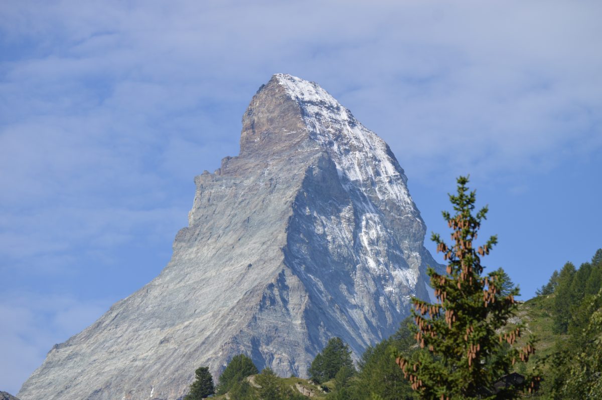
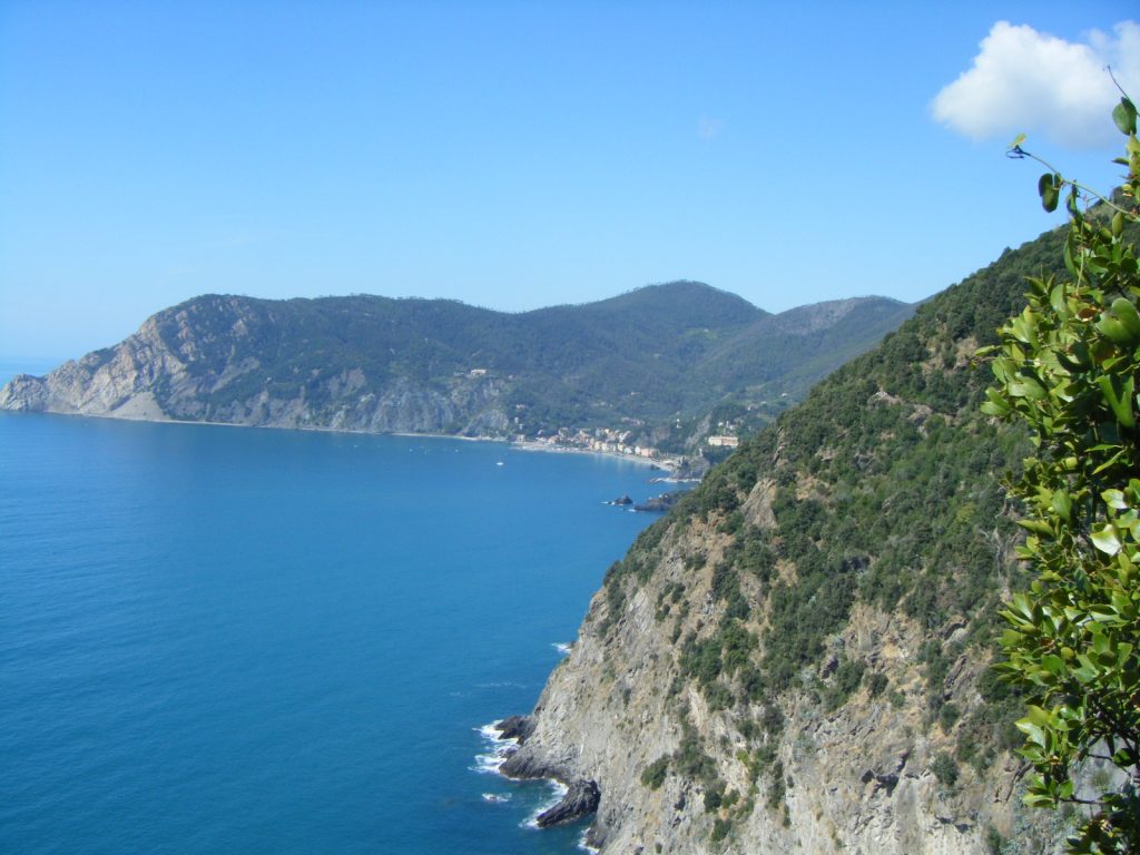
Mountains, Glaciers and Valleys…
The Alps are comprised of many different ranges and groups of mountains. Historically these have been classified differently by countries and organizations. The Partizione delle Alpi of 1926 is used in this table. A SOIUSA plan has been proposed but, not made official.
WESTERN ALPS
Maritime Alps
France, Italy, Monaco
Monte Argentera 10,817
Cottian Alps
France, Italy
Monte Viso 12,602
Graian Alps
France, Italy, Switzerland
Grand Paradiso 13,323
Provence Alps
France
Tête de l’Estrop 9,715
Dauphiné Alps
France
Barre des Écrins 13,458
Provence Prealps
France
Haute Cime 3,257
Dauphiné Prealps
France
l’Obiou 9,150
Savoy Alps
France
Mt. Blanc 15,781
CENTRAL ALPS
Pennine Alps
Italy, Switzerland
Dufourspitze 15,203
Lepontine Alps
Italy, Switzerland
Monte Leone 11,657
Rhaertian Alps
Italy, Liechtenstein, Switzerland
Piz Bernina 13,284
Bernese Alps
Switzerland
Finsteraarhorn 14,022
Glarus Alps
Switzerland
Tödi 11,857
Swiss Prealps
Switzerland
Schilthorn 9,740
Bavarian Alps
Germany
Zugspitze 9,718
Lombard Prealps
Italy, Switzerland
Pizzo di Coca 10,010
EASTERN ALPS
Noric Alps
Austria, Slovenia
Eisenhut 8,009
Dolomites
Italy
Marmolada 10,968
Carnic Alps
Austria, Italy
Coglians 9,127
Julian Alps
Italy, Slovenia
Triglav 9,396
Karavanks
Austria, Slovenia
Hochstuhl / Stol 7,336
Salzburg Alps
Austria, Germany
Hoher Dachstein 9,826
Austrian Alps
Austria
Hochschwab 7,470
Styrian Alps
Austria, Slovenia
Hochter 7772
Venetian Alps
Italy
Col Nudo 8,110
OTHER EUROPEAN MOUNTAIN RANGES…
CARPATHIAN MOUNTAINS
Outer Western
Czechia, Poland
Lysá hora 4,341
Inner Western
Hungary, Slovakia
Gerlachovský štít 8,711
Outer Eastern
Poland, Romania, Ukraine
Hoveria 6,762
Inner Eastern
Poland, Romania, Ukraine
Pietrosu Peak 6,896
Southern
Romania
Moldoveanu 8,346
Romanian
Romania
Bihorul 6,066
APENNINE Mountains
Northern
Italy
Corno Grande 9,554
Central
Italy
Monte Amaro 9,164
Southern
Italy
Serra Dolcedormeonte 7,438
OTHER RANGES
The Ardennes
Belgium, France, Luxembourg
Signal de Batrange 2,277
Balkan Mountains
Bulgaria, Serbia
Botev Peak 7,795
Böhmerwald – Bohemian Forest
Austria, Czechia, Germany
Großer Arber 4,777
Cambrian Mountains
United Kingdom-Wales
Pen Pumlumon Fawr 2,467
Cantabrian Mountians
Spain
Torre de Cerredo 8,668
The Caucasus
Armenia, Azerbaijan, Georgia, Russia
Mt. Elbrus 18,510
Dinaric Alps
Albania, Bosnia & Herzegovina, Croatia, Italy, Montenegro, Serbia, Slovenia
Jezerce 8,839
Erzgebirge – Ore Mountains
Czechia, Germany
Klínovec 4,081
Grampian Mountains
United Kingdom-Scotland
Ben Nevis 4,409
Harz Highland
Germany
Brocken 3,743
Jura Mountains
France, Switzerland
Crêt de la Neige 5,640
Pindus Mountians
Albania, Greece
Smolikas 8,652
The Pyrenees
Andorra, France, Spain
Aneto 11,168
Scandinavian Mountains
Finland, Norway, Sweden
Galdhópiggen 8,100
Sierra Morena
Spain
Bañuela 4,370
Sierra Nevada
Spain
Mulhacén 11,411
The Sudetes
Czechia, Germany, Poland
Sněžka 5,259
Taurus Mountains
Turkey
Demirkazik 12,323
Ural Mountains
Russia
Mount Narodnaya 6,217
The Vosages
France, Germany
Grand Ballon 4,671
Rivers, Lakes & Waterfalls
Europe’s Longest Rivers…
| River | Length | Mouth | Countries |
|---|---|---|---|
| Volga | 3790 | Caspian Sea | Russia |
| Danube | 2857 | Black Sea | Austria, Germany, Hungary, Romania, Serbia, Slovakia |
| Ural | 2428 | Caspian Sea | Russia |
| Dnieper | 2201 | Dnieper-Bug Estuary | Belarus, Russia, Ukraine |
| Don | 1923 | Sea of Azoz | Russia |
| Pechora | 1809 | Pechora Sea | Russia |
| Northern Dvina | 1803 | Dvina Bay | Russia |
| Kur/Kura | 1364 | Caspian Sea | Azerbaijan, Georgia, Turkey |
| Dniester | 1362 | Black Sea | Moldova, Ukraine |
| Elbe | 1329 | Wadden Sea | Czechia, Germany |
| Rhine | 1233 | North Sea | France, Germany, Liechtenstein, Netherlands, Switzerland |
| Vistula | 1211 | Baltic Sea | Poland |
| Oder | 1045 | Baltic Sea | Germany, Poland |
| Daugava | 1020 | Gulf of Riga | Russia |
| Neva | 1010 | Gulf of Finland | Russia |
| Tagus | 1007 | Atlantic Ocean | Portugal, Spain |
| Loire | 1006 | Bay of Biscay | France |
| Mezen | 966 | White Sea | Russia |
| Rhône | 957 | Gulf of Lion | France, Switzerland |
| Meuse/Maas | 950 | North Sea | Belgium, France, Netherlands |
Europe’s Largest Lakes…
Name
Great Britain
Iceland
Ireland
Severny Island
Spitsbergen
Yuzhny Island
Sicily
Sardinia
Nordaustlandet
Cyprus
Corsica
Crete
Zealand
Edgeøya
Kolguyev Island
North Jutlandic
Eubiea
Majorca
Vaygach Island
Funen
Zemlya Georga
Saaremaa
Country
United Kingdom
Iceland
Ireland UK
Russia
Svalbard/Norway
Russia
Italy
Italy
Svalbard/Norway
Cyprus
France
Greece
Denmark
Svalbard/Norway
Russia
Denmark
Greece
Spain
Russia
Denmark
Russia
Estonia
Sq. miles
80,823
39,315
32,595
18,177
15,051
12,836
9,908
9,247
5,586
3,565
3,375
3,220
2,715
1,959
1,918
1,809
1,431
1,416
1,285
1,153
1,089
1,032
Seas – Coastlines – Islands
The Seas in and arounds Europe…
AEGEAN SEA
◼︎Myrtoan Sea
◼︎Argolic Gulf
◼︎Saronic Gulf
◼︎Petalioi Gulf
◼︎South Euboean Gulf
◼︎North Euboean Gulf
◼︎Malian Gulf
◼︎Gulf of Kiparissia
◼︎Pagasetic Gulf
◼︎Thermaic Gulf
◼︎Thracian Sea
◼︎Strymonian Gulf
◼︎Gulf of Saros
◼︎Edremit Gulf
◼︎Gulf of İzmir
◼︎Icarian Sea
◼︎Gulf of Gökova
◼︎Sea of Crete
◼︎Sea of Marmara
◼︎Gulf of İzmit
ADRIATIC SEA
◼︎Gulf of Ambracian (Actium)
◼︎Channel of Vivari
◼︎Bay of Kotor
◼︎Split Channel
◼︎Vinodol Channel
◼︎Gulf of Venice
◼︎Gulf of Trieste
◼︎Venetian Lagoon
◼︎Kvarner Gulf
ARCTIC OCEAN
◼︎Barents Sea
◼︎Kara Strait
◼︎Kara Sea
◼︎Pechora Sea
◼︎White Sea
◼︎Queen Victoria Sea
ATLANTIC OCEAN
◼︎Bantry Bay
◼︎Clew Bay
◼︎Dingle Bay
◼︎Donegal Bay
◼︎Faxa Bay
◼︎Galway Bay
◼︎Kenmare Bay
◼︎BAY OF BISCAY
◼︎Cantabrian Sea
◼︎BLACK SEA
◼︎The Bosporus
◼︎The Dardanelles
◼︎Gulf of Burgas
◼︎Karkinit Bay
◼︎Kalamita Bay
◼︎Sea of Azov
◼︎Syvash
◼︎Taganrog Bay
BALTIC SEA
◼︎Gulf of Bothnia
◼︎Kvarken
◼︎Bothnian Sea
◼︎South Kvarken
◼︎Sea of Åland
◼︎Archipelago Sea
◼︎Gulf of Finland
◼︎Vyborg Bay
◼︎Neva Bay
◼︎Koporye Bay
◼︎Luga Bay
◼︎Narva Bay
◼︎Väinameri Sea
◼︎Gulf of Riga
◼︎Kaliningrad Bay
◼︎Curonian Lagoon
◼︎Vistula Lagoon
◼︎Dziwna
◼︎Strait of Baltiysk
◼︎Gdańsk Bay
◼︎Bay of Pomerania
◼︎Szczecin Lagoon
◼︎Bay of Greifswald
◼︎Rügischer Bodden
◼︎Strelasund
◼︎Bay of Lübeck
◼︎Bay of Kiel
◼︎Kalmar Strait
◼︎Bight of Hanö
◼︎Veerse Gat
◼︎Danish straits
◼︎Oresund Strait
◼︎Fehmarn Belt
◼︎Great Belt
◼︎Little Belt
◼︎GULF OF CÁDIZ
◼︎Bay of Cádiz
◼︎CELTIC SEA
◼︎Bristol Channel
◼︎Iroise Sea
ENGLISH CHANNEL
◼︎Gulf of Saint-Malo
◼︎Strait of Dover
◼︎IRISH SEA
◼︎Cardigan Bay
◼︎Kyles of Bute
◼︎Morecambe Bay
◼︎Firth of Lorn
◼︎Firth of Clude
◼︎Solway Firth
◼︎North Channel
◼︎St. Georges Channel
IONIAN SEA
◼︎Strait of Oranto
◼︎Gulf of Taranto
◼︎Gulf of Corinth
◼︎Messenian Gulf
◼︎Laconian Gulf
MEDITERRANEAN SEA
◼︎Alboran Sea
◼︎Mar Menor
◼︎Balearic Sea
◼︎Gulf of Valencia
◼︎Gulf of Lion
◼︎Étang de Thau
◼︎Ligurian Sea
◼︎Gulf of Genoa
◼︎Tyrrhenian Sea
◼︎Gulf of Naples
◼︎Gulf of Salerno
◼︎Gulf of Cagliari
◼︎Levantine Sea
◼︎Gulf of Antalya
◼︎Gulf of Alexandretta
◼︎Strait of Sicily
◼︎Inland Sea, Gozo
◼︎Sea of Sardinia
◼︎Gulf of Asinara
NORWEGIAN SEA
◼︎Andsfjord
◼︎Aurlandsfjord
◼︎Boknafjord
◼︎Geirangerfjord
◼︎ Hardangerfjord
◼︎Hjørundfjord
◼︎Isfjord
◼︎Kongsfjord
◼︎Lyngenfjord
◼︎Lysefjord
◼︎Melfjord
◼︎Nærøyfjord
◼︎Nordfjord
◼︎Oslofjord
◼︎Porsangerfjord
◼︎Sognefjord
◼︎Romsdalsfjord
◼︎Trollfjord
◼︎Trondheimfjord
◼︎Varangerfjord
◼︎Vestfjord
NORTH SEA
◼︎Vlirstroom
◼︎Kattegat
◼︎Skagerrak
◼︎Wadden Sea
◼︎The Wash
◼︎Dormoch Firth
◼︎Cromarty Firth
◼︎Firth of Fouth
◼︎Moray Firth
◼︎Firth of Tray
◼︎The Wash
Europe’s Largest Islands…
Name
Great Britain
Iceland
Ireland
Severny Island
Spitsbergen
Yuzhny Island
Sicily
Sardinia
Nordaustlandet
Cyprus
Corsica
Crete
Zealand
Edgeøya
Kolguyev Island
North Jutlandic
Eubiea
Majorca
Vaygach Island
Funen
Zemlya Georga
Saaremaa
Country
United Kingdom
Iceland
Ireland UK
Russia
Svalbard/Norway
Russia
Italy
Italy
Svalbard/Norway
Cyprus
France
Greece
Denmark
Svalbard/Norway
Russia
Denmark
Greece
Spain
Russia
Denmark
Russia
Estonia
Sq. miles
80,823
39,315
32,595
18,177
15,051
12,836
9,908
9,247
5,586
3,565
3,375
3,220
2,715
1,959
1,918
1,809
1,431
1,416
1,285
1,153
1,089
1,032
Peninsulas of Europe and the Countries…
Anatolian – Turkey
Balkan – Albania,
Bosnia & Herzegovina, Croatia, Bulgaria, Montenegro, North Macedonia, Greece, Romania, Serbia, Slovenia
Chalkidiki – Greece
Cotentin – France
Crimea – Ukraine
Fennoscandia – Russia
Gallipoli – Turkey
Iberian – Andorra, Gibraltar, Portugal, Spain
Italian – Holy See, Italy, San Marino
Istria – Croatia, Slovenia
Kanin – Russia
Kola – Russia
Peloponnese – Greece
Scandinavian – Norway, Sweden
Tri-Points…
Tri-points are where the borders of three countries meet at one point. Some of these locations are very remote while others very accessible. The easy to get locations have monuments or markers where one can have a little fun by standing in three countries at one time.
The following Tri-Points have markers.
SCHENGEN-DEFRLU
Location: Easy walk access in Schengen, LU, actual border in Moselle, River.
Country Boarders: France, Germany, Luxembourg
THREE-COUNTRY CAIRN-FINOSE
Location: Accessible drive from Skibotn, NO or Kilpisjärvi, FI
Country Boarders: Finland, Norway, Sweden
VAALSERBERG-BEDENL
Location: Easy drive from Vaalserquartier, NL or Gemmenich, BE
Country Boarders: Belgium, Germany, Netherlands
ATHUSK
Location: Short drive Bratislava, SK
Country Boarders: Austria, Hungary, Slovakia
ZITTAU-CZDEPL
Location: Easy drive or hike from Zittau, DE, actual border in Lausiter Neisse River
Country Boarders: Czechia, Germany, Poland
ARNOLDSTEIN-ATITSI
Location: Easy drive or hike from Arnoldstein, AT
Country Boarders: Austria, Italy, Slovenia
NORTH -ATCHLIN
Location: Short drive or hike from Ruggell, LI
Country Boarders: Austria, Liechtenstein, Switzerland
SOUTH-ATCHLIS
Location: No easy access, difficult climb located at 7739 ft on top of Mt. Naafkopf
Country Boarders: Austria, Liechtenstein, Switzerland
ATCZDE
Location: Remote drive and hike from Neureichenau, Germany or Oberschwarzberg, AT
Country Boarders: Austria, Czechia, Germany
BGGRMK
Location: Drive from Platanakia, GR & long hike & climb to site.
Country Boarders: Bulgaria, Greece, North Macedonia
BGGRTK
Location: Short walk from Bugarian/Turkish border crossing at Kaptian Andreeevo, BG
Country Boarders: Bulgaria, Greece, Turkey
BYLTLV
Location:Drive from Turmantas, LT
Country Boarders: Belarus, Latvia, Lithuania
BYLTPL
Location: Drive from Zelwa,PL
Country Boarders: Belarus, Lithuania, Poland
BYLVRU
Location: Easy access from Latvia side- south of Zilupe, LV
Country Boarders: Belarus, Latvia, Russia
CZPLSK
Location: Easy drive & short walk from Hrčava, CZ
Country Boarders: Czechia, Poland, Slovakia
DREILÄNDERECK-CHDEFR
Location: Easy walk access in Klybeck, CH, actual border in Rhine River
Country Boarders: France, Germany, Switzerland
EUROPADENKMAL-BEDELU
Location:Easy drive from Ouren, LU, actual border in Our River on footbridge.
Country Boarders: Belgium, Germany, Luxembourg
HURORS
Location: Short drive from Beba Veche, Romania
Country Boarders: Hungary, Romania, Serbia
The following Tri-Points have no markers.
ALGRMK
Location: In Lake Prespa , boat accessible only
Country Boarders: Albania, Greece, North Macedonia
ALMERS
Location: Considerable drive and difficult hike from Plav, ME or Junik, RS
Country Boarders: Albania, Montenegro, Serbia
ATCZSK
Location: Drive from Hohenau an der March, AT and short hike to confluence of Dyje & Moravy rivers
Country Boarders: Austria, Czechia, Slovakia
BAHRRS
Location: In the middle of Sava river downstream from Brčko, BA. Boat accessible only
Country Boarders: Bosnia & Hercegovina, Croatia, Serbia
BAMERS
Location: Drive from Cajniče, BA, long hike from border crossing to Pejka
Country Boarders: Bosnia & Herzegovina, Montenegro, Serbia
BYPLUA
Location: Boundry in the Bug River short drive from Wlodawa, PL
Country Boarders: Belarus, Poland, Ukraine
EELVRU
Location: Drive from Aluksne, LT and a short walk
Country Boarders: Estonia, Latvia, Russia
HRHURS
Location: Short drive & from Hercegzántó, HU or Backi Breg, RS and hike to river.
Country Boarders: Croatia, Hungary, Serbia
HRHUSI
Location: Drive & Hike from Novakovec, HR. Boundry in Spust River
Country Boarders: Croatia, Hungary, Slovenia
KRZEMIENIEC-PLSKUA
Location: Drive from Nová Sedlica, SK & long hike to site
Country Boarders: Poland, Slovakia, Ukraine
LAKE CONSTANCE-ATCHDE
Location: Lake has easy access, actual border is in the lake, boat accessible only
Country Boarders: Austria, German, Switzerland
LTPLRU
Location: Drive from Zytkiejmy, PL & short walk
Country Boarders: Lithuania, Poland, Russia
MUOTKAVAARA-FINORU
Location: 5km hike access from Grensefoss, NO
Country Boarders: Finland, Norway, Russia
MT. DOLENT-CHFRIT
Location: In-accssible, lies at 3,749 metres, nw of the summit of Mont Dolent
Country Boarders: France, Italy, Switzerland